I often clean up my computers a bit at the end of the year and especially get rid of video footage which is not really needed. I try to live with 20 Terabyte drives for a while. Freeing a few 100 gig of summer footage helps. Pictures were taken on May 31, 2025:
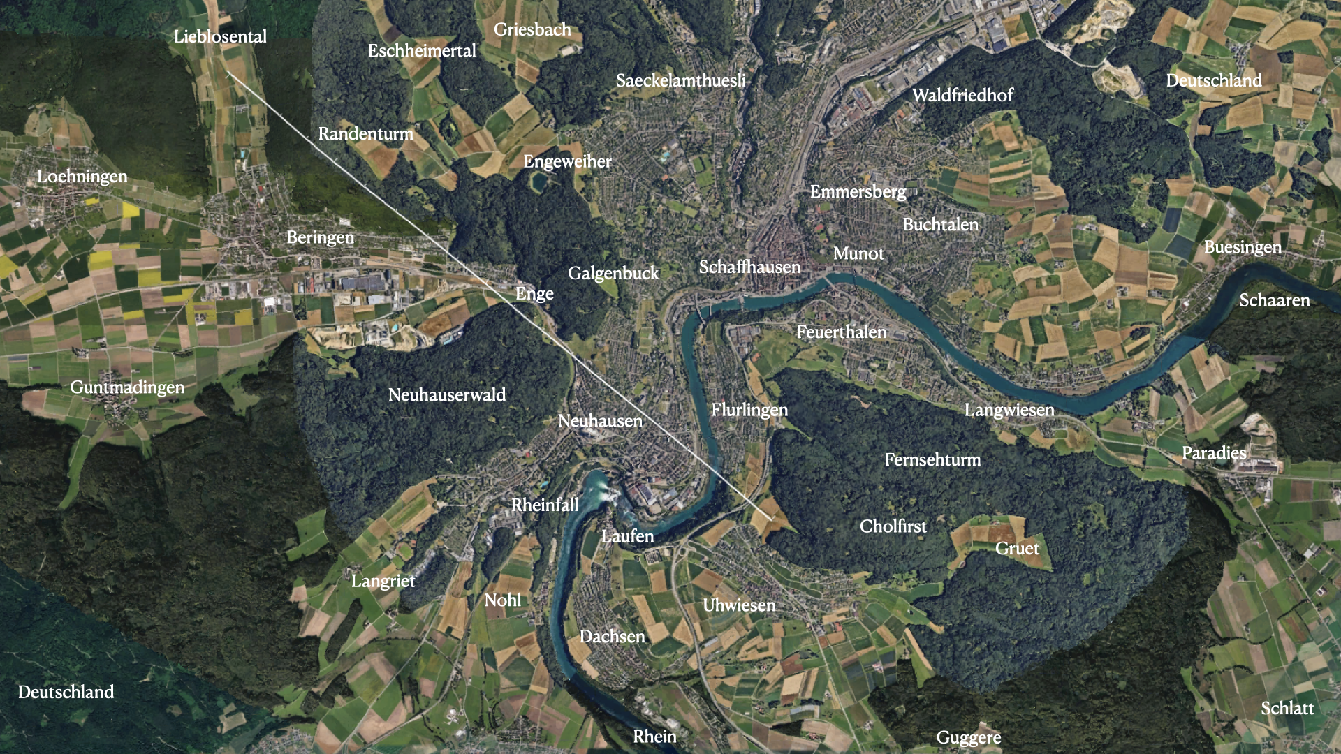
00:00:05 we cross the Rhein between Flurlingen and Neuhausen. Flurlingen is nice to swim in the rhein. I sometimes would come back from college and walk home to Uhwiesen along the Rhein or put my cloths into a waterproof bag and swim down from schaffhausen to Flurlingen then walk the rest. To the very left, left of the large high rise building lived both my grand parents. Both of my parents have grown up in Neuhausen. I know the town pretty well too. We also mostly took the train to Zuerich from Neuhausen (the station is near the river bridge visible.
00:00:20 we get close to the Enge. To the right is the âGalgenbuckâ (where in ancient times people were hanged!) The forest to the left we know from when we were visiting my grandparents in Neubergstrasse 33.
00:00:40 we reach Beringen. It recently got a big data center. To the right is already the âRandenâ, a wonderful large area great for recreation, walking, biking, running, skiing or cross country skiing. There are also nice hats. Our class once spent a few days in one of these hats to prepare for the Matura finals.
00:01:10 the Beringer Randentum (a tower to climb on to see the view) comes up. The forest around especially to the right is the ârandenâ. To the left the Siblinger Randen, to the right the Beringer randen. You might notice the white streets. They are not asphalt but covered with local stone (which is chalk stone). One can find fosslis there if one is lucky.
00:01:35 we return over the Lieblosental (I do not take risks. The machine could have flown much further but the amount of cash I can spend on drones is limited. I do not want to lose it).
00:01:45 just after making a U turn, we see in the middle the Cholfirst (the forest surrounded by the towns of Langwiesen, Feuerthalen, Flurlingen, Uhwiesen, Benken. To the right is again Beringen, left down the Beringer Randenturm. To the left the randen with the white street, in the background Schaffhausen.
00:01:55 We have also time to look at the mountains. We directly fly towards the Santis (we sometimes skied there). Then the Churfirsten (we had our first School trip in first grade there and the entire class climbed the Hinterugg). More to the right the Toedi. If the whether would be clearer, we would see the Eiger-Moench-Jungfrau.
00:02:15 We see the entrance of the "Galgenbuck tunnel". When I had been a kid this was not yet there and Neuhausen had a big traffic problem. The tunnel made it better. To the very left Schaffhausen, where I went to high school. We see to the left a smaller antenna tower (which I climed once free solo) and in the Cholfirst the big Antenna tower (which we also climbed a few times to the top.
00:02:30 In the background the "weinland", the weincountry. One can see also Frauenfeld, where I did my military time. To the left the rhein, where we would frequenly be on the boat, once pushing us up (without motor) to Stein am Rhein at the beginning of the lake of Konstanz.
00:02:35 we fly over the Rosenberg middle school, where many of my friends in high school had been in middle school. The rheinfalls are to the right. The forest above the rhein is the "Buechhalde". Very steep, we would often build hats there or fight the gangs of the neighbor village or go fishing .The big forest to the left is the Cholfirst. I know every square meter there and can run it at night without moonlight. I often did and once stumbled over a hoard of wild pigs.
00:03:00 Uhwiesen to the right, where I grew up. There is a big construction going on now (a new gym) as one can see. Just below is where my parents built a house.
00:03:11. The big farm is "Eichenberger". The farmer had been going to school with my brother. To the right is Benken a neighbor town.
00:03:25 Just before turning one can see an other observation tower above Wildensbuch. It was not yet there when I was a kid, but I have been running there since a few times too. To the right is Benken and a famous restaurant the "guggere" with a wonderful view over the vine country.
00:03:28. After turning we see Uhwiesen to the left. Kindergarden was to the very left at the boundary of the village (I was not a single time, not even the first time to find it going there with a parent). We were taught to be independent early. in the middle of the town is the primary school, where I spent 6 years. It is a beautiful view over Uhwiesen from here with the rheinfalls close by.
00:03:35 The "Uhwieser Hoernli" an other wooden observation tower is visible at the bottom.
00:03:40 We will land again at the "Bruderer field", where also various entrance points to the forest split. The little house at the vertex of the triangular wedge had been storing amunition for the military. It is called "Pulverhueseli" Powder house.